visitorfromthefuture
  • VIDEO
  • TEXT
  • PAST
  • FUTURE
Select Page
  • VIDEO
  • TEXT
  • PAST
  • FUTURE

Walkley Road

Street in Ottawa, Canada
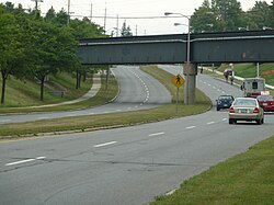
Walkley Road looking east going under the Via Rail bridge

Walkley Road (Ottawa Road #74) is a major road in Ottawa, Ontario, Canada. It runs from Riverside Drive to Ramseyville Road (formerly Baseline Road). It is mostly a four-lane divided road which runs through both residential and industrial areas of the southern part of urban Ottawa.

See also

  • List of roads in Ottawa

External links

KML file ( • help)
Template:Attached KML/Walkley Road
KML is from Wikidata
  • Ottawa 2020 Transportation Master Plan
Roads in Ottawa
Provincial highways
  • 7
  • 416
  • 417
Numbered / arterial roads
  • Airport
  • Albion
  • Alta Vista
  • Bank
  • Baseline
  • Blair
  • Bronson
  • Carling
  • Carp
  • Cedarview
  • Conroy
  • Donnelly
  • Dwyer Hill
  • Eagleson
  • Elgin
  • Fourth Line
  • Hazeldean
  • Heron
  • Hunt Club
  • Innes
  • Kent
  • King Edward
  • Laurier
  • Lees
  • Merivale
  • Metcalfe
  • Mitch Owens
  • Montreal
  • Nicholas
  • O'Connor
  • Parkdale
  • Preston
  • Prince of Wales
  • Regional Road 174
  • Queen
  • Richmond
  • Rideau
  • River
  • Riverside
  • Robertson
  • Russell
  • St. Joseph
  • St. Laurent
  • Smyth
  • Somerset
  • Strandherd
  • Sussex
  • Tenth Line
  • Terry Fox
  • Trim
  • Vanier
  • Walkley
  • Wellington
  • Woodroffe
Collector roads
  • Brookfield
  • Gladstone
  • Hog's Back
  • Meadowlands
  • Old Prescott
  • Sparks
Federal parkways
  • Aviation
  • Colonel By
  • Island Park
  • Kichi Zibi Mikan
  • Queen Elizabeth
  • Sir George-Étienne Cartier
Roads in Ontario