File:Walachia.png
No higher resolution available.
Walachia.png (302 × 225 pixels, file size: 12 KB, MIME type: image/png)
Summary
| Geotemporal data | ||||||||||
| Bounding box |
|
|||||||||
| Georeferencing | ||||||||||

|
File:Walachia.svg is a vector version of this file. It should be used in place of this PNG file when not inferior.
File:Walachia.png → File:Walachia.svg
For more information, see Help:SVG. |
 |
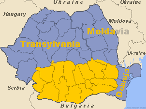
Map of Romania with Wallachia highlighted
Source: Made by me

|
Permission is granted to copy, distribute and/or modify this document under the terms of the GNU Free Documentation License, Version 1.2 or any later version published by the Free Software Foundation; with no Invariant Sections, no Front-Cover Texts, and no Back-Cover Texts. A copy of the license is included in the section entitled GNU Free Documentation License. |
| This file is licensed under the Creative Commons Attribution-Share Alike 3.0 Unported license. | ||
| ||
| This licensing tag was added to this file as part of the GFDL licensing update. |
File history
Click on a date/time to view the file as it appeared at that time.
| Date/Time | Thumbnail | Dimensions | User | Comment | |
|---|---|---|---|---|---|
| current | 14:29, 10 July 2016 | | 302 × 225 (12 KB) | Julieta39 | More details |
| 19:27, 30 October 2005 |  | 302 × 225 (10 KB) | Kirk979 | Corrected map of Walachia | |
| 19:25, 30 October 2005 |  | 302 × 225 (10 KB) | Kirk979 | ||
| 17:52, 18 April 2005 |  | 302 × 225 (10 KB) | Bogdan | Map of Romania with Wallachia highlighted Source: Made by me {{GFDL}} Category:Maps of Romania\ |
File usage
The following 2 pages use this file:
Global file usage
The following other wikis use this file:
- Usage on be-tarask.wikipedia.org
- Usage on be.wikipedia.org
- Usage on bg.wikipedia.org
- Usage on bs.wikipedia.org
- Usage on ca.wikipedia.org
- Usage on cs.wikipedia.org
- Usage on da.wikipedia.org
- Usage on de.wikipedia.org
- Usage on el.wikipedia.org
- Usage on en.wiktionary.org
- Usage on eo.wikipedia.org
- Usage on et.wikipedia.org
- Usage on fa.wikipedia.org
- Usage on fi.wikipedia.org
- Usage on gd.wikipedia.org
- Usage on he.wikipedia.org
- Usage on hr.wikipedia.org
- Usage on hu.wiktionary.org
- Usage on hy.wikipedia.org
- Usage on hyw.wikipedia.org
- Usage on ie.wikipedia.org
- Usage on is.wikipedia.org
- Usage on it.wikivoyage.org
- Usage on ja.wikipedia.org
- Usage on ka.wikipedia.org
- Usage on kk.wikipedia.org
- Usage on ko.wikipedia.org
- Usage on ku.wikipedia.org
- Usage on la.wikipedia.org
View more global usage of this file.