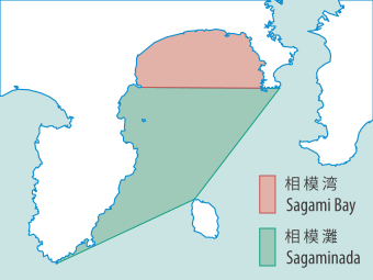
File:Sagami Bay Location map 20161105.svg

Size of this PNG preview of this SVG file: 340 × 255 pixels. Other resolutions: 320 × 240 pixels | 640 × 480 pixels | 1,024 × 768 pixels | 1,280 × 960 pixels | 2,560 × 1,920 pixels.
Original file (SVG file, nominally 340 × 255 pixels, file size: 32 KB)
File history
Click on a date/time to view the file as it appeared at that time.
| Date/Time | Thumbnail | Dimensions | User | Comment | |
|---|---|---|---|---|---|
| current | 11:10, 5 November 2016 |  | 340 × 255 (32 KB) | Batholith | {{Information |Description= {{en|Location map of '''Sagami Bay''', Japan.}} {{ja|'''相模湾'''の範囲図。}} |Source=Own work using *File:Japan Kanto adm location map.svg |Author=[[:User:Batholith|Bath... |
File usage
The following 2 pages use this file:
Global file usage
The following other wikis use this file:
- Usage on ar.wikipedia.org
- Usage on ca.wikipedia.org
- Usage on eu.wikipedia.org
- Usage on fa.wikipedia.org
- Usage on hy.wikipedia.org
- Usage on it.wikipedia.org
- Usage on ja.wikipedia.org
- Usage on ko.wikipedia.org
- Usage on nl.wikipedia.org
- Usage on www.wikidata.org
